On March 1, Li Xiaopeng, Minister of Transportation, explained in detail the recently issued Outline of the National Integrated Three-dimensional Transportation Network at the press conference of the State Council Office that it is estimated that by 2035, the scale of the national integrated three-dimensional transportation network will reach about 700,000 kilometers.

On March 1, Li Xiaopeng, Minister of Transportation, explained in detail the National Comprehensive Three-dimensional Transportation Network Planning Outline recently issued. The Paper reporter Zhou Yushe
Li Xiaopeng said that among them, there are about 200,000 kilometers of railways, 460,000 kilometers of highways, 25,000 kilometers of high-grade waterways, 27 major coastal ports, 36 major inland ports, 400 civil transport airports and 80 postal express hubs.
Li Xiaopeng said that the national comprehensive three-dimensional transportation network will build the main skeleton of a comprehensive three-dimensional network with "6 axes, 7 corridors and 8 channels".
Li Xiaopeng said that according to the national regional development strategy, the pattern of land space development and protection, especially the traffic demand and traffic time and space distribution forecast of key areas, key areas can be divided into three types. The first type is the economic circle of Beijing-Tianjin-Hebei, Yangtze River Delta, Guangdong-Hong Kong-Macao Greater Bay Area and Chengdu-Chongqing, which has four "poles". In addition to the 4 poles, there are 8 groups and 9 groups.
Li Xiaopeng said that first of all, six comprehensive, large-capacity, high-speed, multi-channel and three-dimensional spindles should be used to connect these four "poles" to form six axes. In addition, there are 7 corridors between "Pole" and "Group" and "Group", and 8 channels between "Group" and "Group", which are "6 axes, 7 corridors and 8 channels".
Li Xiaopeng said that in the future, it is necessary to speed up the construction of hubs and simultaneously build comprehensive transportation hub clusters, hub cities and hub ports. Four "poles" — — The twin-city economic circle in Beijing-Tianjin-Hebei, Yangtze River Delta, Guangdong-Hong Kong-Macao Greater Bay Area and Chengdu-Chongqing will build four international hub clusters, and about 20 international hub cities and 80 national hub cities will be built to form about 100 comprehensive three-dimensional transportation hubs.
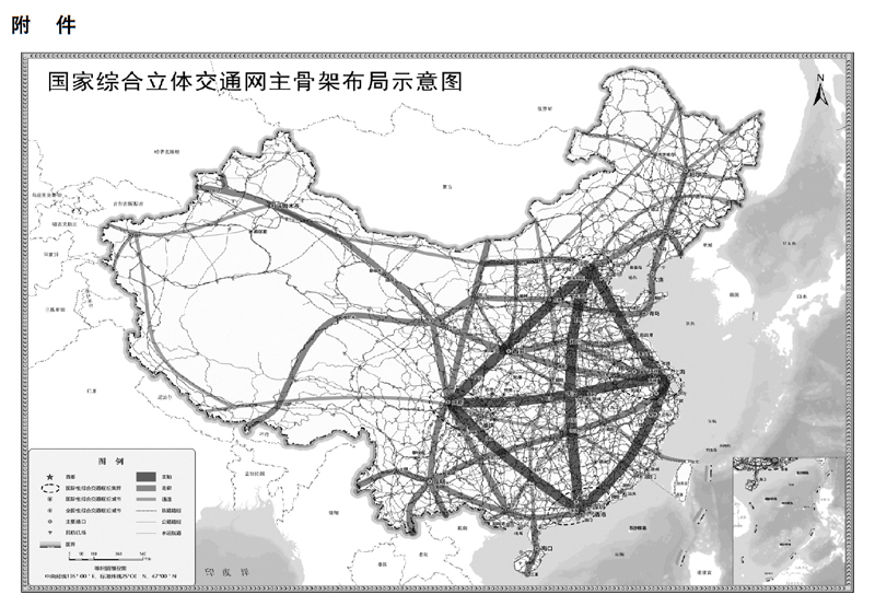
Schematic diagram of the main skeleton layout of the national comprehensive three-dimensional transportation network
According to the National Comprehensive Three-dimensional Traffic Network Planning Outline issued by the Central Committee of the Communist Party of China and the State Council a few days ago, seven corridors and eight passages are as follows:
Accelerate the construction of seven corridors. Strengthen the radiation function of the four poles in the economic circle of Beijing-Tianjin-Hebei, Yangtze River Delta, Guangdong-Hong Kong-Macao Greater Bay Area and Chengdu-Chongqing, strengthen the connection between poles and groups, build multi-modal, multi-channel and convenient transportation corridors such as Beijing-Harbin, Beijing-Tibet, Continental Bridge, western land and sea, Shanghai-Kunming, Chengdu-Chongqing-Kunming and Guangzhou-Kunming, and optimize and improve the multi-center and networked main skeleton structure.
Accelerate the construction of eight channels. Strengthen the connection and coordination between the main shaft and the corridor, strengthen the connection between groups and groups, strengthen the connection coverage of resource industry gathering places and important ports, and build traffic passages such as Suiman, Jingyan, Bianbian, Fuyin, Erzhan, Sichuan-Tibet, Xianggui and Xiamen-Rong, so as to promote internal and external connectivity and access to the sea, and expand the coverage of traffic networks in the central and western regions and northeast regions.
关于作者